Drone GPR: Zond Aero ground penetrating radar for DJI drones, prices and buying guide
DroneBase integrates Radar Systems Zond Aero NG drone GPR systems on DJI Matrice 300/350 RTK platforms for utility mapping, archaeology, geotechnics and environmental surveys. This page explains what drives the price of a ground penetrating radar, how to choose between 500 and 1000 MHz antennas and what you need to fly: instrument, carrier drone, onboard computer, software and training.
What is a drone GPR
A ground penetrating radar (GPR), also called georadar, sends electromagnetic pulses into the ground and records reflections from objects and material changes: pipes, cables, voids, foundations, geological layers. The output is a radargram, a vertical section of the subsurface along the survey line. Mounted on a drone, a GPR covers large or hard-to-reach areas with regular, georeferenced profiles.
Radar Systems Inc. Zond Aero NG units are professional single-unit GPRs with a built-in shielded antenna and Real Time Sampling technology: dynamic range up to 138 dB, hardware stacking up to 65,536 times and up to 2,500 scans per second. The same instruments also work on the ground, in the protective case with integrated Li-Ion battery and WiFi.
Drone GPR price: what a ground penetrating radar drone system costs
The price of a professional drone GPR is more than the instrument alone. The cost drivers are:
- Instrument and antenna: frequency (500 or 1000 MHz) defines the model. The standard Zond Aero 500 NG kit is listed from €21,959 and the standard Zond Aero 1000 NG kit from €24,399, both including 22% Italian VAT.
- Carrier drone: if you already fly a DJI Matrice 300 or 350 RTK the standard kit is enough; otherwise the Drone Combo Kits are listed at €46,359 (500 NG) and €48,799 (1000 NG) including VAT.
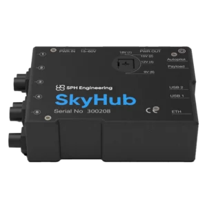
- Onboard computer: UgCS SkyHub 3 handles constant height above ground (True Terrain Following), synchronised geotagging and data logging; it is listed at €2,899 including VAT.
- Software: Prism 2 acquisition and processing software is included in the Zond Aero kits; data are output in standard SEG-Y format.
- RTK positioning: traces are geotagged; an RTK drone makes profile positions more accurate, a requirement for reliable maps.
- Training and commissioning: GPR principles, flight planning, Prism 2 and radargram interpretation, defined in the quote.
With the same instrument, total cost can vary widely between a team that already owns DJI Matrice drones and one starting from scratch. We size the configuration on your survey depths and target types.
How to choose a GPR: frequency, depth and resolution
The rule of thumb: higher frequency means better resolution but less depth. A 1000 MHz antenna resolves small, shallow targets; a 500 MHz antenna reaches deeper with less detail. Soil conductivity and moisture reduce penetration: clays and saturated soils absorb the signal, dry sands let it through.
| Feature | Zond Aero 500 NG | Zond Aero 1000 NG |
| Centre frequency | 500 MHz | 1000 MHz |
| Resolution × depth (manufacturer data) | 0.4 m × 4 m | 0.1 m × 2-3 m |
| Time range | 18-8,192 ns | 5-4,096 ns |
| Scans per second | up to 2,500 | up to 2,500 |
| Best for | Deeper surveys, geology, voids | Utilities, shallow structures, archaeology |
| Standard kit list price | from €21,959 incl. VAT | from €24,399 incl. VAT |
Depth and resolution are stated by Radar Systems Inc. for soil with relative permittivity 4 and attenuation of 1-2 dB/m and should be read as reference values.
Drone GPR integration with DJI Matrice and SkyHub
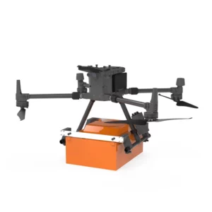
Zond Aero NG kits include the mount for the DJI Matrice 350 RTK and Matrice 300 RTK; in flight the GPR is powered by the drone battery and sends data over Ethernet. Mounts for other drones are available on request. Airborne GPR surveys need a low, constant height above ground: the SkyHub 3 onboard computer reads the altimeter, holds the drone at the set height and synchronises every trace with position. As a system integrator we configure drone, GPR and onboard computer and deliver them tested.
3D GPR: how a subsurface map is built
A single-channel GPR records 2D profiles. A 3D view of the subsurface is reconstructed by acquiring closely spaced parallel profiles on a regular grid and combining them in post-processing into horizontal time-slices and volumes. Automatic terrain-following flight and geotagged traces make the grid repeatable, so the cost of a 3D survey depends more on planning, line density and processing than on the instrument.
Applications
- Utility mapping: pipes, cables and buried services before excavation.
- Archaeology: non-invasive surveys of buried structures and artefacts.
- Geotechnics and civil engineering: foundations, ground stability, voids.
- Environment and geology: stratigraphy, groundwater, subsurface characterisation.
- Civil protection and security: support to search and rescue and to investigations of buried objects.
Drone GPR price: frequently asked questions
How much does a drone GPR cost?
For a professional Zond Aero NG drone GPR, standard kits are listed from €21,959 (500 NG) and from €24,399 (1000 NG) including 22% Italian VAT. Carrier drone, SkyHub onboard computer and training are added where needed.
What is the price of a GPR with the drone included?
The Drone Combo Kits are listed at €46,359 for the Zond Aero 500 NG and €48,799 for the Zond Aero 1000 NG, including VAT. If you already own a DJI Matrice 300 or 350 RTK you can start from the standard kit.
Is there an affordable drone GPR?
The entry point in this category is the standard Zond Aero 500 NG kit. The most effective way to control cost is to reuse a DJI Matrice 300/350 RTK you already own and size the configuration on the depths you actually need.
What is the difference between GPR and georadar?
None: GPR stands for ground penetrating radar, and georadar is the name used in many European markets for the same instrument.
Should I choose a 500 or 1000 MHz GPR?
The 1000 MHz unit gives about 0.1 m resolution down to 2-3 m and suits utilities and shallow structures; the 500 MHz unit reaches about 4 m with 0.4 m resolution. Manufacturer values in reference soil.
How much does a 3D GPR survey cost?
With a single-channel GPR the 3D view comes from parallel grid profiles processed into time-slices. The instrument is the same: cost depends on flight planning, line density and processing software, which we assess per project.
Which drones are compatible with Zond Aero GPRs?
The kits include mounts for the DJI Matrice 300 RTK and Matrice 350 RTK, powered by the drone battery. Mounts for other drones are available on request.
Do I need an onboard computer to fly a GPR?
Airborne GPR surveys need a low, constant height above ground and data synchronised with position: this is the job of UgCS SkyHub 3, with True Terrain Following and SEG-Y data logging.
Does the price include software and training?
Prism 2 acquisition and processing software is included in the Zond Aero kits. Operator training, commissioning and technical support are defined in the quote based on your team's experience.
Need to know which GPR configuration fits your project and what it costs overall? Tell us survey depth, target type and the drone you already use and we will send a detailed quote. Phone +39 0541.1790411.
Georadar
Showing all 3 results
Georadar
2 products-
✓ Ready to shipGeoradar, Georadar & Magnetometer Combo, UgCS - SPH
Georadar Drone – Zond Aero 1000 NG GPR
Ultra-lightweight GPR system for geophysical and archaeological surveying on DJI Matrice 300/350. Single unit with Ethernet and WiFi connectivity for real-time analysis. Available at DroneBase, DJI Gold 5 Dealer.
SKU: n/a -
✓ Ready to ship
Onboard Computer
1 productView full category →-
✓ Ready to ship